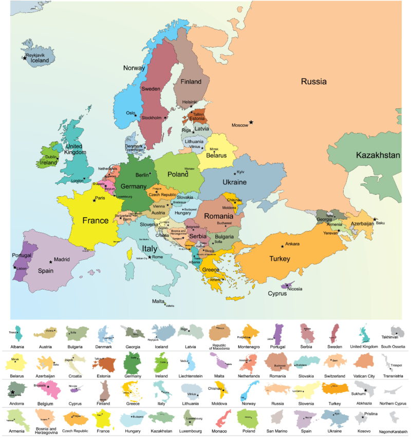
Europe is special continent, and that is why everyone should know. That’s why we bring you a rich selection of the best map of Europe to download.
Europe is in contrast to Africa or Asia quite a small continent. Still extremely interesting and intricate . Thanks to its natural wealth and favorable climate, Europe has become a very rich area, triggering the greatest expansion of humanity . To this day, Europe is amazed by its diversity, which is also incorporated into one of the main slogans of the European Union:
“United in diversity.”
Facts about Europe
It is almost unbelievable how many states (46), nationalities and languages are crammed on such a small continent.
All those amazing mountains, rivers, lakes, lowlands, islands, and other interesting formations.
Europe covers an area of 10,180,000 km² . With Europe’s borders, it’s a little more complicated because it’s directly connected to Asia. For example, countries in the Caucasus (Georgia, Armenia, Azerbaijan) are sometimes included in Europe and sometimes not. There are professional discussions from the Strahlenberg border to the borders of the former USSR, which are differences in hundreds of thousands of square kilometers.
Maps of Europe for download
Map of European countries (JPG, size 504 kb, resolution 3,000 x 2,754 px) – Clear and graphically very tasteful map of all European countries. Only some of those mosques are omitted (San Marino, Liechtenstein, Andorra).
Geographic map of Europe (JPG, size 1503 kb, resolution 3,000 x 2,944 px) – Physical geographic map of all major mountains, lowlands, rivers, lakes, etc.
Simple map of European states (JPG, 470k size, 3,000 x 2,386px resolution) – Another map of states, this time with small flags.
Map of the European Union (JPG, 633 kb, 3,000 x 3,089 px) – The European Union is a key political and economic integration on the European continent. However, this nice map is no longer valid. The United Kingdom emerged in 2020.
Flags of European countries (JPG, size 608 kb, resolution 1,234 x 2,382 px) – An interesting creative map where the outlines of states are filled with their flags. You can even find marked capitals on this map.
Europe countries map (JPG, size 283 kb, resolution 1,234 x 1,192 px) – A comprehensive map of Europe from Wikipedia, which tries to leave out nothing.
Europe Blind Map (JPG, 239k, 1,234 x 1,193 px) – A nice blind map to help with geography games or geography lessons with orientation training.
Borders and countries of Europe map (JPG, 972 548 kb, resolution 3,000 x 3,206 px) – A slightly different view of the European continent, where individual states are cut out of the natural context.
Physical map of Europe (JPG, size 615 kb, resolution 1,234 x 1,272 px) – A physical, almost satellite map of Europe. Very detailed and interesting.
Map of European cities and states (JPG, size 859 kb, 3,000 x 2,998 px resolution) – Another nice map of states at the end. On this map, it’s great that it also shows smaller cities.
What to use our maps for
- Improve your orientation on your home continent.
- For teaching geography (such as a blind map). Or take notes.
- For easy navigation – deciding where to go on holiday.
Maps of Europe online
Need to see Europe in much more detail? So we can definitely recommend the following online maps. You can play them on your computer and on your mobile phone and examine them in detail nicely down to the smallest detail. Clicking on the following links will open a map of Europe directly.
- Google Maps (Europe) – Detail maps with many layers.
- Mapy.cz (Europe) – Clear and useful maps.
Maps of Europe summary
On this page, we’ve put together a pretty rich selection of maps of Europe . Maybe we managed to hit what you need. Of course, we’re just happy to share your thoughts or recommendations with us on what another map of Europe you’ll still use . Of course, you can get something and we will try to satisfy me if it is within our means.
We have prepared maps of Europe for you purely for educational purposes . Download them and use them however you want, just please don’t spread them.


